>
Sponsored Find a Solicitor — free quotes via ReallyMoving
Land
Station Road, Stalbridge
Land Planning
£6,000,000
Next Steps
Sponsored — free quotes via ReallyMoving
Find a Solicitor
Land purchases need specialist legal advice — compare fees
Our Summary
- Residential development land with outline planning permission for up to 160 dwellings
- 25 acres) with outline planning permission for up to 160 dwellings and open public space Location - The site is located on the eastern edge of Stalbridge, approximately 0
- Planning Permission And Development - Outline Planning Permission was granted on Appeal reference APP/D1265/W/23/3333249, on planning reference P/OUT/2023/02643 by Dorset Council, for up to 160 No
- The Data Room will include the following: -Complete suite of technical reports and surveys -Planning application submission including approved plans -Ground investigation report -Title and Land Registry details -Utilities information -Bidding template An agreed list of reports and surveys will be assigned to the purchaser on legal completion and a Letter of Reliance provided from external consultants
- Overage And Special Conditions - The bidding template invites prospective purchasers to include overage/value uplift provision as part of their offer
Get alerted when similar properties are listed — Subscribe
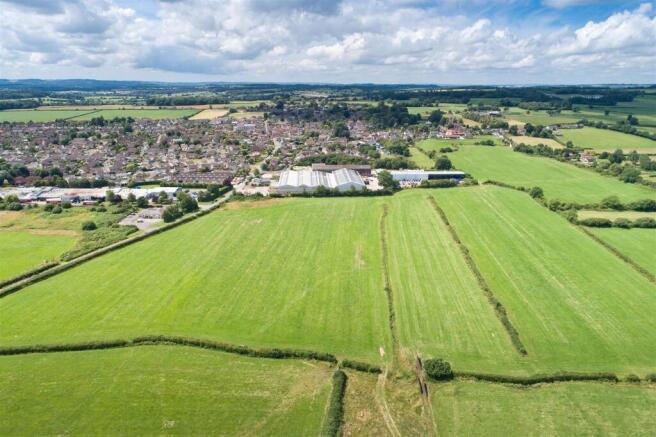
Description
The property is a development site extending to approximately 20.74 hectares (51.25 acres) with a mix of approximately 11.31 hectares of development area and 9.47 hectares of Biodiversity Net Gain area. The site is generally fairly level and comprises agricultural land with hedge boundaries. It has two public footpaths crossing the site and is bounded by Station Road to the south, open countryside to the north and east, and a small industrial estate to the west.